Worst DC Road Sign Ever
I am still fighting off some kind of plague that I most likely contracted from spending all day Tuesday in the freezing cold in close proximity to thousands of disease-carrying tourists, so I don't feel like finishing my inauguration story just yet. But as a brief aside, a complaint about DC roads.
DC's network of highways must be absolutely baffling for tourists (including those who live in MD and NoVa). This in itself is not a problem; quite the opposite, it's what makes DC so car-friendly. I depend on this fact to get around town with relative ease even during peak traffic times. Seems most people have never heard of such roads as Rock Creek Parkway, Broad Branch Road, Oregon Avenue, Kansas Avenue, to name a few very useful routes that are, to varying degrees, sparsely traveled. Hey, your "lost" is my gain. Have fun sitting in traffic on 16th Street or 395, suckers.
But there is a line. My walk under the Capitol last Tuesday gave me an opportunity to photograph the most egregious of all roadsigns in DC. And believe me, from the almost-invisible brown signs on RCP or Beach Drive, to the upside-down Irving Street Westbound sign when exiting North Capitol Street, there are many candidates. But this one takes the cake, both in terms of it's utter uselessness, and the consequences when you go the wrong way as a result. Or alternatively get in to an accident trying to figure out which way to go.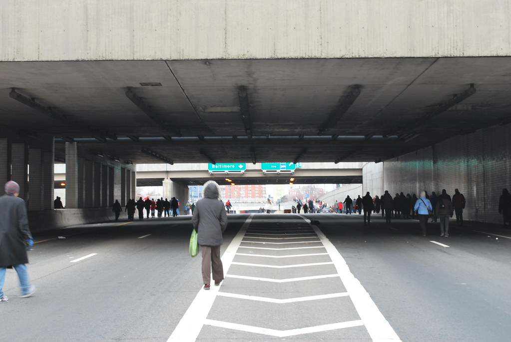
Behold, the Exit from 395 North to either Massachusetts Avenue or New York Avenue.
As you will note, at the position I took this photograph, I am already way too far ahead to legally pick a side. At this point, all I can tell is that the left lane goes to Baltimore. Even as a long-time DC resident, that is still not enough information while traveling at 35 MPH (or faster) to figure out which side I should be on, since I am not typically going to Baltimore at this point.
By the time you can actually read the street sign, to figure out which way is which, you are staring down a giant concrete median and you've got a swath of no-man's road at least 20 feet wide to dart across to the other side if you got it wrong. If that's even remotely practical because there are a gazillion cars going 50 MPH all around you.
Seriously. Why the HELL isn't this sign placed, oh, say, ON THE EMPTY WALL DIRECTLY ABOVE ME? Or anywhere else that is actually at a point that can be seen in advance of when you have to decide?
And worst of all -- when you make the wrong choice, especially if there's a lot of traffic (which there often is down there) you are screwed. It can take 20 minutes or more to recover from that blunder.
FAIL.
![]()
1 comment:
I am glad you were able to take a picture of this. I am so with you! I have been in this spot many times and it seems the attitude of the planner was "Eff 'em. They just have to know." Because there is no way to get useful information from those signs. You just have to know where you are supposed to be. FAIL, indeed.
Post a Comment